Alabama’s Weather Forecast: Dry, chilly air blows in this weekend
Afternoon highs rebound into the 70s this week before our next blast of cold air arrives.
Check the video forecast for the latest updates.
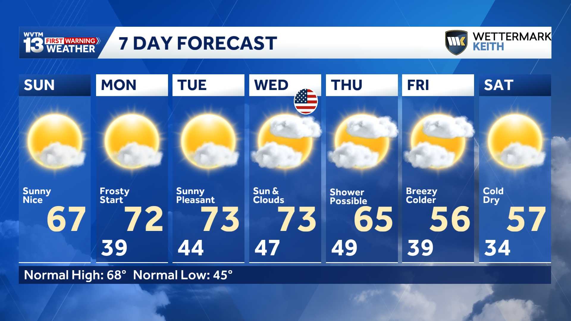
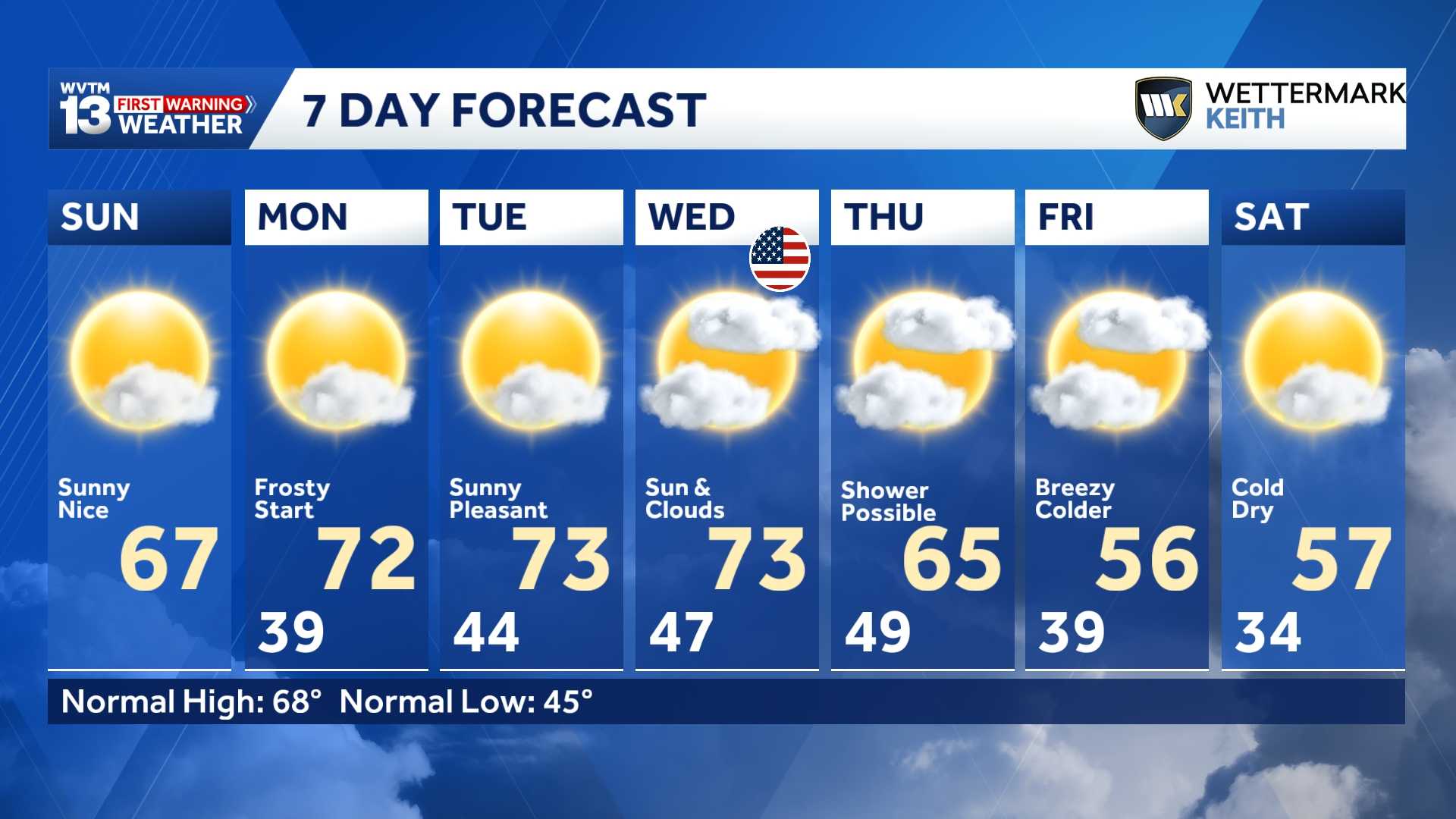
7-DAY FORECAST
SUNDAY: It will be another sunny day with highs in the mid-to-upper 60s. Rain chance: 0%.
MONDAY: Partly cloudy. Highs around 70 degrees. Rain chance: Near 0%.
TUESDAY: Partly sunny. Warmer in the afternoon with highs in the 70s and a low chance of rain over the southeastern part of the state. Rain chance: Near 0%
WEDNESDAY (VETERANS DAY): Sun and clouds. Highs in the lower 70s. Rain chance: 10%.
THURSDAY: High temperatures near average in the mid-60s after a chilly morning. Spotty shower possible ahead of an approaching cold front. Rain chance: 20%
FRIDAY: Turning sharply colder again with highs only in the 50s and 60s. Steady northwest breeze 10-15 mph. Rain chance: 0%
SATURDAY: A sunny but very cold fall day. Lows in the 30s, highs in the 50s. Rain chance: 0%
Temperatures will rebound into the upper 60s Sunday afternoon, which is near average for this time of year.
Bring potted plants inside again Sunday night, and make sure outdoor pets have proper shelter. Many areas across North Alabama will flirt with the freezing mark early Monday morning.
NEXT WEEK AND VETERANS DAY
Another round of frost is possible Monday morning as temperatures drop into the 30s across Central and North Alabama. Highs will recover nicely into the low 70s under mostly sunny skies. Expect mild afternoons to continue through midweek, while mornings remain chilly in the low-to-mid 40s through Wednesday.
Veterans Day 2026 will feature fantastic weather for the nation’s oldest Veterans Day parade in downtown Birmingham at 1 p.m. Temperatures will be in the 70s, under a mix of sun and clouds.
A STRONGER SHOT OF COLD
Looking ahead, another strong cold front is expected to arrive between next Thursday and Friday (Nov. 12–13) with a sharp temperature change likely to follow. A few sprinkles or light showers may develop ahead of the front, but we don’t expect anything of consequence.
A strong blast of cold air arrives behind this front, bringing renewed chances of frost and freezing temperatures. This one looks pretty impressive—highs next Saturday might not escape the 50s, with wind chills driving feels-like temperatures into the 40s all day.
We will provide more specific details on local impacts as confidence in the forecast increases.
The latest 6-to-10 day temperature outlook from the Climate Prediction Center features an interesting trend for the region. Odds favor below-average temperatures across the Deep South and down into the Florida Peninsula, signaling a noticeable push of colder air heading into mid-November.
For 12 consecutive years, WVTM 13 First Warning Weather has been the source for the certified most accurate forecasts in Central Alabama, showcasing an unwavering commitment to delivering dependable weather updates.
WVTM 13 is available on all platforms, ensuring you can access accurate weather updates whenever and wherever you need them. Whether it’s on TV, social media or through our free mobile app, you’ll stay connected to the latest forecasts and alerts.
“We always prepare you for what’s next. Warning you first to every weather change in every forecast. It’s our commitment to you.”