
The wild side of Little Rock: New trail connections near Lake Maumelle lure city slickers out of town
For Central Arkansas residents, getting out into the remote wilderness has, until recently, meant packing up the car and hoofing it up to the Ozarks or trekking deep into the Ouachita Mountains. Not anymore.
Say hello to 13.5 miles of new trails just west of the city that track through pristine oak and pine forests and wind along the undeveloped shores of Lake Maumelle. These pathways, which officially open Oct. 19, stitch together Blue Mountain, Rattlesnake Ridge and Pinnacle Mountain, and are surprisingly pristine and secluded — and just minutes from the city.
The Nature Conservancy worked with Central Arkansas Water, the Arkansas Natural Heritage Commission, Arkansas State Parks, the Office of Outdoor Recreation and the Arkansas Game and Fish Commission on the new trail system, which took under a year to complete and was funded through a federal grant with a match from the water utility and the state of Arkansas.
Bryan Rupar, Central Arkansas Water’s watershed protection manager, said the trails are ideal for anyone looking for a wilder, more rugged outdoor adventure. It’s the first time a trail has cut this deep into the water utility’s land around the south side of the lake, giving hikers a little-traveled and up-close view of our drinking water. “Water is so vital to public health, to our economic growth and stability, and just our everyday life. It’s hard to understate the value of that resource,” he said.
On a very hot mid-September day, we became some of the first laypeople to hike the entire South Lake Trail, a smooth, gently rolling but challenging 9.8-mile stretch that runs from WestRock Landing Marina along Lake Maumelle over to the Pinnacle Mountain Visitor Center. Three spurs connect the lake path back to Rattlesnake Ridge and Blue Mountain natural areas, making for a customizable adventure.
You’ll need to do some advanced planning. Bathrooms are available at the marina and visitor center, but along the way, there are no bathrooms, campsites or water refill stations — and few off-ramps. What this trek lacks in creature comforts, however, it makes up for in unspoiled nature and solitude just minutes from the city.
9 a.m. — I meet two friends, Rebecca and Jenny, at the Pinnacle Mountain Visitor Center, 30 minutes from downtown Little Rock. We leave one car at the visitor center and drove 12 minutes over to WestRock Landing Marina on Lake Maumelle, where we park the second car. One quick tip: If you’re shuttling, make sure to bring the keys on the hike — otherwise, you may find yourself hitchhiking back to your starting point.
The marina parking lot is undergoing construction, and the water utility is also building a new office. Don’t let the construction throw you off — there are still places to park, and you’re in the right spot.
9:15 a.m. — After stocking up on more water at the marina store, which has a small selection of drinks and snacks, we hit the trail. The trailhead is near the highway, just past the entrance gate on the right.
The hike starts mostly flat with pretty marina views and quickly gives way to a beautiful shaded pine and oak forest at a slightly higher elevation that should have stunning fall foliage. About a mile in, the sounds of the highway fade into near-total serenity.
9:50 a.m. — At the 1.3-mile mark, we reach the offshoot for the Pygmy Trail, the new connector that runs to Blue Mountain Natural Area. This intersection is a little confusing, so we double-check the trail map on our phones. We track our progress using the MTB Project mountain biking trail app — and the trails should appear on AllTrails soon as well. By the time readers hit the trail, there should be signage.
We encounter more mountain bikers on this section. South Lake Trail has good sightlines, however, and isn’t particularly steep, so you should have no trouble spotting bikes and hopping out of the way. Around the 2-mile mark, there’s another new spur that connects to Rattlesnake Ridge Natural Area.
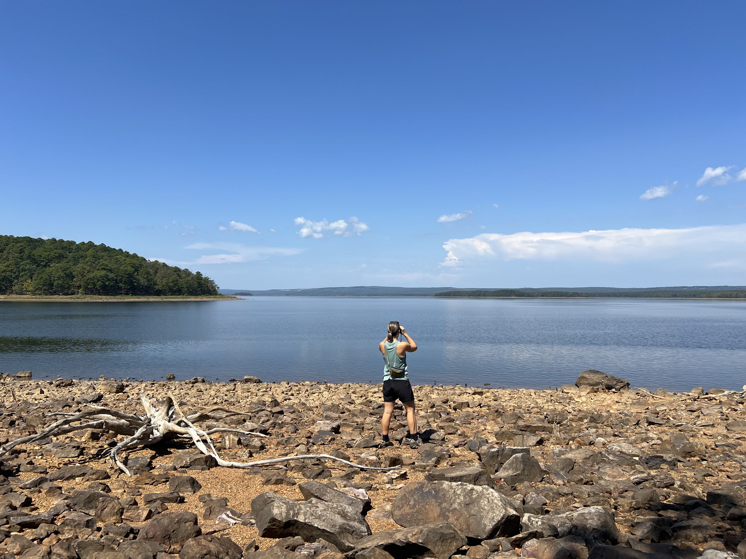
11:17 a.m. — About halfway into the hike, the trail drops back down and hugs the shoreline of Lake Maumelle — we find ourselves staring into a wide expanse of water surrounded by deep green forest, with only a few homes visible on the opposite crest. We’re staring at the reservoir that supplies much of the region’s drinking water — and has strict no-body-contact rules, so no swimming, jet skis or even dipping a hand in the water, to help keep it clean.
The lake is way down due to drought, which is a tad alarming. Rupar said that while our drinking water levels aren’t in danger, low levels mean little boat activity, which makes for an exceptionally peaceful hike.
In the winter, Lake Maumelle is a haven for migrating waterfowl, including bufflehead ducks, loons and mergansers. Just as we’re starting to feel sorry for ourselves for spotting so few birds, an osprey soars overhead.
Noon — Back on the trail, we wind around the lake before heading back into the woods. This section has exposed sections, and wearing sunscreen is advised. We see plenty of critters, including a baby eastern hog-nosed snake, large grasshoppers and copious daddy longlegs walking along the path.
My friend Jenny, a master naturalist, points out that there are remarkably few invasive plant species, like nandina and privet, and she notices many native plants, like American beautyberry, beakgrass and ferns. I spot native wildflowers, including camphorweed.
1:38 p.m. — About 7 miles into the hike, we cross the final new spur, the Drip Torch Trail, which runs to Rattlesnake Ridge. The trail’s name, Rupar said, references the tool forest managers use for prescribed burns, which helps the woods we’re adventuring through to resist wildfires, pests and diseases.
“A drip torch is our main ignition tool,” Rupar said. “We’ve got to have fire on that landscape to keep that habitat going and our trees as healthy as possible.”
Throughout the hike, we notice char on the bottom portion of trees and a thinned-out understory, which I might add is convenient for finding a spot to go in the woods without sitting in poison ivy (just remember to pack out toilet paper and other garbage).
The final section features rolling hills with rocky outcrops. The path is built to the natural contours of the hills, which Rupar said helps manage erosion and runoff, and means we don’t tax our very-tired legs.
2:18 p.m. — Highway noise becomes audible again, and, at last, we emerge from the woods at the intersection of Arkansas Highway 300 and Pence Drive. Here, you’ll need to cross over the highway to get back to Pinnacle Center Visitor Center. Cars fly down this road, so be very careful crossing. Once across, the trail continues just up a gravel road to the right. From there, it’s just a 2-minute walk through the woods to the visitor center: an air-conditioned oasis with bathrooms, water fountains and a well-appointed gift shop with snacks and drinks.
2:30 p.m. — We conquer the trail in about 5 hours walking at a medium 2-mile-an-hour pace. We are drenched in sweat, running on fumes and have consumed every drop of water we packed — our readers, thankfully, will get to set out on this gorgeous hike in more comfortable weather. Jenny refills her water bottle, I buy myself a cup of Loblolly ice cream from the gift shop, and Rebecca snags an Arkansas State Parks hat.
After a quick drive back to the marina to get the second car, we’re done for the day and have the rest of the afternoon to enjoy. The best part of outdoor adventuring close to home is you can ice your tired muscles and sleep in your soft bed, or if you have a deep well of energy like my friends, you can go home, shower and hit the town afterward.
The 10-mile hike survival guide
Tackling a 10-mile hike deep in the woods takes some advanced planning. Make sure to wear good hiking boots or comfortable sneakers and pack as light as you can. Wear sunscreen on exposed skin and think through the comfort and coolness of each article of clothing, down to your underwear and socks — even minor irritations can chafe after several hours. My friends and I each brought our own stash of toilet paper, calorie-dense snacks and a light lunch — and lots of water. It was sweltering on our hike, well over 90 degrees and humid, so we were drinking constantly. Surprisingly, there weren’t many bugs, so bug spray wasn’t needed.
Elizabeth’s packing list:
Eddie Bauer mini-backpack
Cell phone for photos, trail maps and emergencies
Sunglasses
Ball cap
Car keys
3 liters of water with electrolytes
2 Clif Bar Minis
1 peanut butter and jelly on a tortilla
1 snack-size bag of Cheez-Its
1 snack-size bag of Ritz Bits
Results: I had plenty of food and just enough water. Next time, I would switch one salty snack for a piece of fruit. I would switch my Eddie Bauer backpack for an option with a smooth back, as the mesh fabric started to irritate my skin after several miles. I would also leave my sunglasses and hat at home, as most of the trail was covered and it added extra weight.
Hours and admission
Free. South Lake Trail is open year-round, and access isn’t restricted to certain hours of the day. Be mindful of ”trail closed” signs, as parts of the trail are under construction or closed during wet weather. Check the Central Arkansas Water Lake Maumelle website for up-to-date information.
Amenities
Bathrooms and water can be found at WestRock Landing Marina and the Pinnacle Mountain Visitor Center. Water bottles can be refilled at the visitor center and are available for purchase at the visitor center and marina.
Rules
No camping. No e-bikes. Pack all trash in and out. Lake Maumelle is part of the Maumelle River Wildlife Management Area, and in hunting season, it’s a good idea to wear orange.
Source link