
Alabama Weather Forecast: Hot and dry with few storms
Alabama’s September heat wave continues into the weekend and next week with few thunderstorms in the forecast
This month is the hottest September on record so far. The extreme heat will last into the weekend, but a slight pattern change will bring temperatures down a little next week.
Check the video forecast for the latest updates.
7-DAY FORECAST
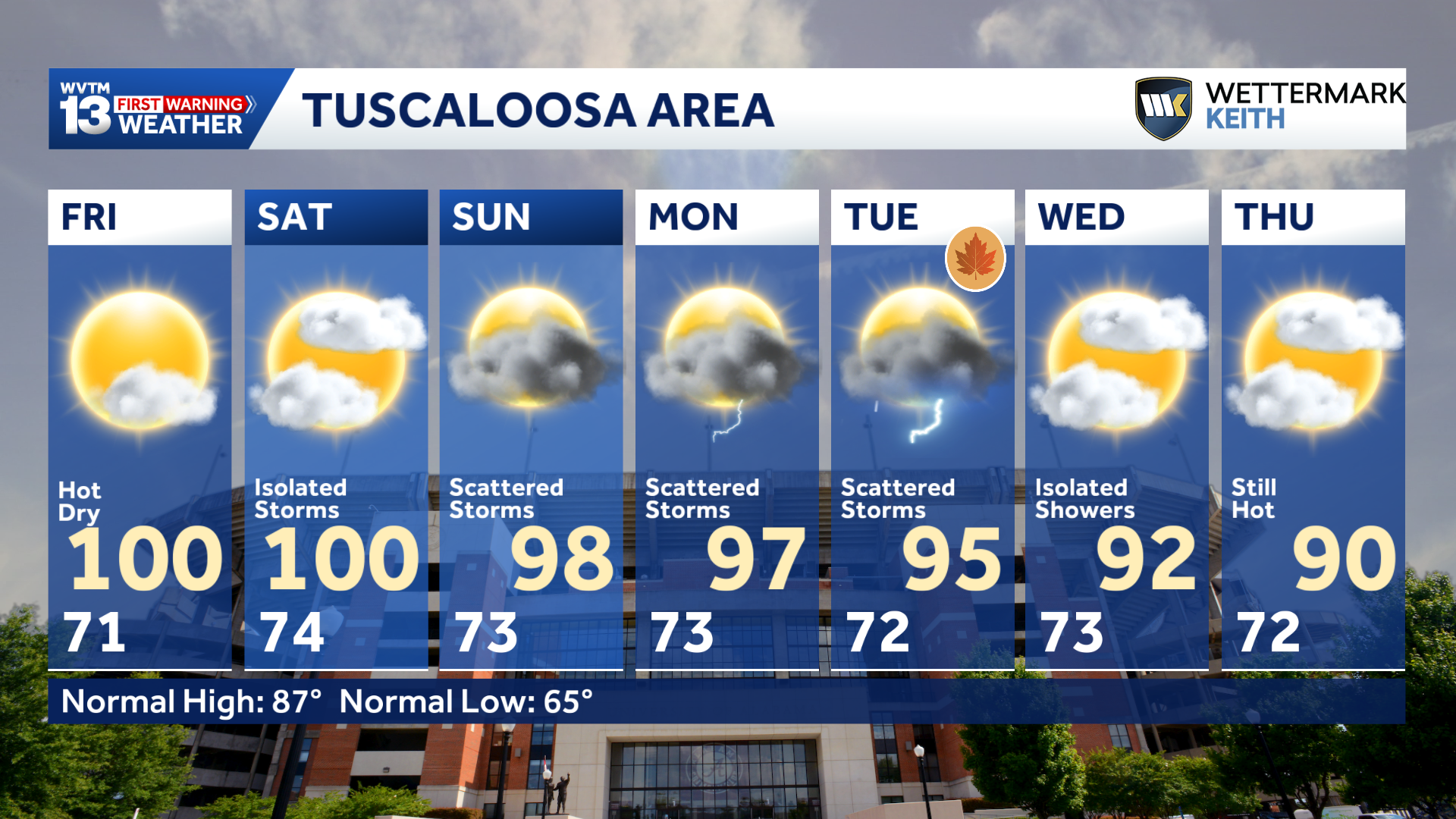
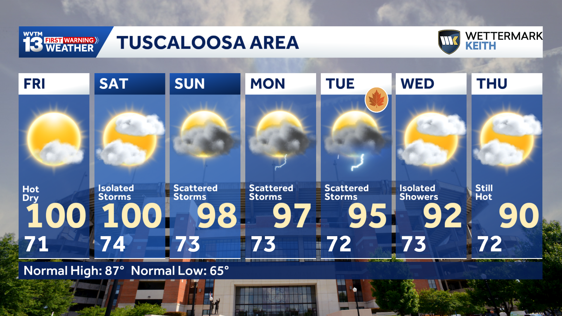
FRIDAY: Very hot again. A few isolated thunderstorms in the afternoon and evening, especially over eastern Alabama. Rain chance: 20%.
SATURDAY: Partly sunny and very hot again. Highs in the upper 90s with a chance of some scattered heavy thunderstorms, especially over eastern Alabama in the afternoon and evening. Rain chance: 30%.
SUNDAY: Partly sunny and hot. Scattered showers and thunderstorms possible. Highs in the middle 90s. Rain chance: 30%.
MONDAY: Fair and hot. A few scattered thunderstorms possible. Highs in the lower to middle 90s. Rain chance: 30%.
TUESDAY: A few scattered storms, otherwise unusually hot weather continues. Highs in the lower to middle 90s. Rain chance: 30%.
WEDNESDAY: Partly sunny and still hot for late September. Highs around 90 degrees with a limited chance of some spotty showers and storms. Rain chance: 20%.
THURSDAY: Mostly sunny. Not quite as hot with highs between 85 and 90 degrees and lows in the upper 60s to lower 70s. Rain chance: 10%.
BENCHMARK SEPTEMBER HEAT
September 2026 now stands alone as the hottest September on record in Birmingham since 1895, and there is very little chance of cool weather knocking it out of the top spot before the end of the month.
September 1925 featured higher afternoon temperature peaks, including seven consecutive days above 100 degrees and two days that reached 106. This year’s heat has been much more persistent, with no daily high below 90 degrees since Aug. 27. We have at least six or seven days to go before there is any chance of a high below 90.
FRIDAY AND THE WEEKEND
An east wind held temperatures down a little Thursday. The fact that the lower 90s in eastern Alabama counts as a cooldown shows how intense and long-lasting this heat wave has been.
On Friday, the wind will shift to the north, and it will get hotter again. A dry north wind can often mean the difference between a hot day and a record-setting one.
The record high in Birmingham for Friday is 101 degrees, set in 1925 and 1927. The forecast calls for a high in the upper 90s in the Birmingham area, but Tuscaloosa could come a little closer to a record. The Sept. 18 record at Tuscaloosa National Airport is 102 degrees, set in 1927.
There will be a slight chance of widely scattered storms Friday afternoon and evening, mainly east of Interstate 65. However, most high school football games will be free of any significant thunderstorm threat this week.
Saturday will still be hot enough to challenge some record highs.
Birmingham’s forecast calls for a high of 97 degrees, with a record high of 102 set in 1931. Tuscaloosa’s forecast high of 100 degrees will be within one degree of the record of 101, set in 1927 and 1931.
Records or not, this will be an extremely hot weekend for late September.
Widely scattered storms will develop Saturday afternoon, mainly across eastern and southeastern Alabama. The Storm Prediction Center has issued a marginal risk for a few severe storms, with locally damaging winds being the main concern.
Most spots will remain dry Saturday, but for some areas, this will be the best chance for rain in quite a while.
Sunday will remain hot, but temperatures will come down slightly. Expect highs in the lower to mid-90s, with scattered showers and storms focused primarily across eastern Alabama.
WHEN WILL IT GET COOL?
Fall will officially begin in Alabama on Tuesday, Sept. 22, at 7:04 p.m. CDT.
Our forecast for fall’s arrival features fair skies, a low chance of a shower or storm and a high of 92 degrees. That is 8 degrees above average for Sept. 22.
There are some signs that the heat will ease, but that is not the same as expecting cool weather. All short- and medium-range forecast model guidance points to modest cooling, if any, through the end of the month. Birmingham and Tuscaloosa could continue to experience daytime highs above 90 degrees for another full week before temperatures cool enough to return to normal for this time of year.
Birmingham’s normal temperatures for the fall equinox on Sept. 22 are a high of 84 degrees and a low of 64. Probability forecasts show, at best, a 40% chance of a high that low within the next 10 days.
Birmingham’s final 90-degree day of the season usually occurs around Sept. 20, but at this point, temperatures in the 90s could potentially last into October this year.
COLLEGE FOOTBALL FORECAST
Alabama hosting Florida State: Expect partly sunny skies and intense heat for Saturday’s 2:30 p.m. CDT kickoff at Bryant-Denny Stadium. The rain chance sits near 10% at game time, rising to near 20% late in the afternoon. Kickoff temperatures will begin near 100 degrees with a light northerly breeze, sliding into the lower 90s by the fourth quarter.
Auburn hosting Florida: Rain chances have increased in Auburn ahead of Saturday’s 6 p.m. CDT kickoff at Jordan-Hare Stadium. The chance of rain will be around 50% starting in the early to midafternoon, but if a storm develops, it could cause a lightning delay again this week. A light northwest breeze will accompany temperatures falling from near 87 degrees at kickoff into the upper 70s by the end of the game.
Jacksonville State hosting Georgia Southern: Expect a fair, warm evening for Saturday’s 6 p.m. CDT kickoff at AmFirst Stadium. The chance of rain is around 30% for tailgaters and at kickoff, but should drop rather fast. The temperature will start out in the upper 80s at kickoff with a light east breeze, dropping to around 80 by the fourth quarter.
Troy at Missouri: Expect hot, mostly sunny weather in Columbia ahead of Saturday’s 6 p.m. CDT kickoff. The rain chance will be around 10% with a light southerly breeze. Kickoff temperatures will start near 91 degrees, cooling to near 82 degrees by the fourth quarter.
UAB at Louisiana: Clear, dry conditions and lingering late-summer heat will prevail for Saturday’s 7 p.m. CDT kickoff at Cajun Field in Lafayette. Rain is unlikely under mainly clear skies. The temperature will be near the upper 80s at kickoff with a light southeasterly breeze, cooling to around 80 by the end of regulation.
Miles at Clark Atlanta: Warm, dry conditions will greet fans in Atlanta for Saturday’s 5 p.m. CDT kickoff. Expect partly sunny skies and around a 10% chance of rain. A light easterly breeze will accompany temperatures near 90 at kickoff before temps drop to around 80 by the fourth quarter.
For 12 consecutive years, WVTM 13 First Warning Weather has been the source for the certified most accurate forecasts in Central Alabama, showcasing an unwavering commitment to delivering dependable weather updates.