
Typhoon No. 26 Approaches Okinawa With Fierce Winds
NAHA –
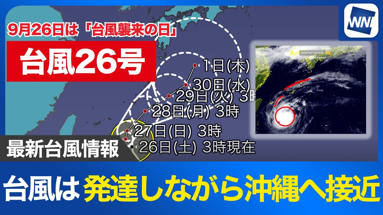
Typhoon No. 26 is moving north-northwest over waters south of Okinawa and is expected to intensify into a strong typhoon by September 27, bringing powerful winds, heavy rain and waves exceeding 6 meters as it approaches the region early next week, according to the latest forecast issued at 5 a.m. on September 26.
The storm is currently traveling at approximately 15 kilometers per hour and has not yet developed a storm-force wind zone. However, it is forecast to strengthen rapidly, with maximum sustained winds reaching 35 meters per second by 3 a.m. on September 27.
Satellite imagery shows a large, circular mass of clouds over waters south of Okinawa, with its outer cloud bands already extending northward toward the Amami Islands. The storm’s main rain clouds, however, remain considerably farther south.
The typhoon is expected to gradually turn northward as it strengthens, approaching Okinawa’s main island before changing direction toward the northeast. Its strongest impact on Okinawa is forecast between September 28 and September 29, when powerful winds and heavy rain could bring prolonged stormy conditions.
By 3 a.m. on September 28, the typhoon is expected to be southeast of Okinawa’s main island, with maximum sustained winds reaching 40 meters per second. Its relatively slow movement near Okinawa raises concerns that severe weather could persist for an extended period.
Meteorologists warn that typhoons can produce dangerous winds and heavy rainfall well beyond their centers, meaning areas outside the storm’s immediate path could also experience significant impacts. Residents are being urged to complete preparations early and remain alert to changing weather conditions.
Coastal areas will begin experiencing deteriorating conditions well before the storm reaches its closest point. Waves around Okinawa are forecast to exceed 2 meters during September 26, posing increasing risks to swimming, boating and other marine activities.
Conditions are expected to worsen on September 27, when waves of more than 3 meters are forecast, particularly around Okinawa’s main island.
By September 28, waves could exceed 6 meters as the typhoon approaches, creating extremely rough seas and dangerous conditions along exposed coastlines. People are being advised to avoid approaching the sea during the period of severe weather.
Marine activities around Okinawa and the southern Amami Islands are expected to become increasingly hazardous, with particularly dangerous conditions forecast from September 28 onward.
Beyond its initial approach to Okinawa, the typhoon is expected to gradually move northeastward. Forecasts indicate that it could still maintain strong typhoon intensity on October 1, with maximum sustained winds of approximately 35 meters per second.
However, considerable uncertainty remains over its subsequent course. Forecast models currently show substantial differences in the storm’s projected track, reflected in an unusually large forecast area for the beginning of October.
The typhoon is also expected to slow considerably next week, increasing the possibility that its effects on Okinawa could last longer than initially anticipated.
Although a northeastward movement is considered the general forecast direction, the storm could follow a more complicated path depending on developing atmospheric conditions.
Its eventual track could also bring impacts to parts of Honshu, although the extent and timing of any potential effects remain uncertain.
Residents of Okinawa and surrounding islands are being urged to monitor the latest typhoon information, particularly as the storm strengthens and its projected course becomes clearer over the coming days.
Source: ウェザーニュース